Below is a detailed, comprehensive article on flash flood warnings. It is organized into multiple sections to cover the concept, causes, detection, warnings systems, public response, case studies, challenges, and recommendations. You can use this as a base and expand or localize it (for Cambodia or your region) if needed.
Table of Contents
-
Introduction
-
Flash Floods: Definition, Characteristics, and Dynamics
-
Causes and Contributing Factors
-
Detection, Monitoring, and Prediction
-
The Warning Chain: From Forecast to Public Alert
-
Types of Warnings and Their Meanings
-
Public Response, Preparedness, and Safety Measures
-
Challenges and Limitations in Flash Flood Warning Systems
-
Case Studies and Examples
-
Lessons Learned and Best Practices
-
Recommendations for Improvement
-
Conclusion
1. Introduction
Flash floods are among the most sudden and destructive natural hazards. Unlike slower-onset flooding where warnings may be issued hours or days in advance, flash floods can occur within minutes, leaving little time for response. For this reason, issuing timely and accurate flash flood warnings is critical for saving lives, minimizing injuries, and reducing damage to property and infrastructure.
This article explores every aspect of flash flood warnings: what they are, how they work, the science behind them, how people should respond, the challenges in issuing them, and examples of successes and failures.
2. Flash Floods: Definition, Characteristics, and Dynamics
Definition
A flash flood is a sudden, short-duration flood that typically occurs within a few minutes to a few hours of excessive rainfall, dam/levee failure, or other hydrologic triggers. It is characterized by the rapid rise of water in streams, dry washes, urban drainage systems, and low-lying areas.
The term “flash” emphasizes the speed with which they can initiate and rise — often too fast for those in the path to react.
Distinguishing Flash Floods from Other Flood Types
| Feature | Flash Flood | Riverine / Slow-onset Flood |
|---|---|---|
| Time to develop | Minutes to few hours | Hours to days |
| Area of impact | Typically smaller, localized | Larger, affecting entire river basins |
| Warning lead time | Short (rarely more than a few hours) | Longer (sometimes many hours to days) |
| Primary cause | Intense rainfall, dam break, urban runoff | Prolonged rainfall, snowmelt, upstream flow accumulation |
| Human response | Rapid evacuation, immediate action | Gradual preparation, controlled evacuations |
Flash floods also differ from coastal flooding, which is driven by storm surge or tidal effects, and from landslides (though landslides may accompany flash floods in some settings).
Hydrologic Behavior and Dynamics
The intensity and speed of flash flooding depend on:
-
Rainfall intensity and duration: Very heavy rainfall in a short period can overwhelm natural and artificial drainage.
-
Topography: Steep slopes funnel water rapidly into channels and valleys.
-
Soil conditions: Saturated or impermeable soils allow more runoff; dry soils may absorb more until saturated.
-
Land cover and vegetation: Areas with less vegetation or urban surfaces (concrete, asphalt) lead to more fast runoff.
-
Drainage network and channel geometry: Narrow gullies, small channels, or constricted passages lead to faster rises.
-
Antecedent moisture: If soils are already saturated from prior rain, even moderate additional rain can trigger flash floods.
Because of these factors, flash floods may occur even when no rain is falling in your immediate vicinity (rain upstream may funnel into your area).
3. Causes and Contributing Factors
Understanding what triggers flash floods is vital to forecasting and issuing warnings.
Heavy Rainfall (Convective Storms, Thunderstorms)
One of the most common causes is intense, localized rainfall—especially from convective thunderstorms. When downpours concentrate over small basins, runoff can far exceed what the terrain and drainage can handle.
Short Rainfall Duration but High Intensity
Even if total rainfall is not huge, if it falls in a short time, the runoff may be devastatingly rapid.
Terrain and Slope
Regions with steep terrain (hills, mountains) are especially susceptible. Rainfall on slopes quickly converts into runoff, cascading into downstream areas.
Urbanization and Impermeable Surfaces
Cities and urban areas exacerbate flash flooding risk. Roads, parking lots, rooftops, and other impermeable surfaces prevent infiltration and direct water rapidly into drains and waterways.
Upstream Rainfall / Watersheds
Rain falling upstream—perhaps in a different area or even in a different catchment—can feed into river systems and channels that impact downstream communities, causing flooding even where local rainfall was mild.
Dam, Levee, or Infrastructure Failures
Breaks in dams, levee breaches, or failure of retention basins can instantly release stored water, triggering a flash flood downstream.
Blockages and Debris Accumulation
Natural or human-caused blockages (fallen trees, debris, landslides) in channels or culverts can obstruct flow, redirect water, or cause sudden surges when a dam-like blockage fails.
Soil Saturation / Antecedent Conditions
When the soil is already saturated from prior rain, its capacity to absorb more water is minimal, so new rain becomes runoff almost immediately.
Snowmelt or Ice Jams (in colder climates)
Rapid melting or ice jams breaking can cause sudden releases of water.
4. Detection, Monitoring, and Prediction
To issue effective flash flood warnings, meteorological and hydrological monitoring is essential. Here are key systems and methods involved.
Rain Gauges and Automated Rainfall Networks
These ground-based sensors measure precipitation amounts and rates in real time. Data from rain gauges allow estimation of how much water is being delivered to a basin.
Radar and Satellite Remote Sensing
Weather radar (especially Doppler radar) identifies precipitation intensity, motion, and structure, helping forecasters estimate rainfall rates over wide areas. Satellite sensors complement this by providing broader coverage, especially in remote regions.
Streamflow and River-Gauge Networks
Stream gauges record water levels and discharge in rivers and streams. Rapid rises in water levels are key indicators that a flood is underway or imminent.
Flash Flood Guidance Systems (FFGS)
These are specialized hydrologic models and algorithms that relate rainfall inputs to runoff potential. They compute threshold rainfall depths over particular durations for basins (e.g. 1- to 6-hour windows) beyond which flooding is likely.
In essence, the flash flood guidance system helps forecasters understand how much rain a given basin can absorb before flooding begins, given soil moisture, basin size, and other conditions.
Hydrologic and Hydrodynamic Modeling
Using soil data, topography, land cover, channel geometry, and precipitation forecasts, models simulate flow behavior, potential inundation areas, and timings.
Nowcasting and Short-Range Forecasting
Given the very short lead times involved, prediction often relies on “nowcasting” — using recent observations (radar, gauge) along with extrapolation to anticipate flood onset in the immediate future (minutes to few hours ahead).
Integrating Data Streams and Decision Support Tools
Modern warning systems often integrate radar, gauge, forecast model data, and rainfall-runoff modeling into decision support systems, which assist meteorologists and hydrologists in determining when and where to issue flash flood warnings.
5. The Warning Chain: From Forecast to Public Alert
A flash flood warning is only as effective as the chain of processes behind it. Here’s how a typical warning chain works:
-
Data Collection & Monitoring
Real-time observations (radar, gauges, sensors) feed into models and situational awareness tools. -
Analysis & Forecasting
Hydrologists and meteorologists analyze data, run models, and evaluate risk thresholds. Using flash flood guidance systems, they assess whether rain and runoff will push conditions over thresholds. -
Decision to Issue Warning
When a risk crosses defined criteria (e.g., predicted water beyond bankfull thresholds, or observed rapid rises), forecasts issue a warning. Agencies may coordinate with local disaster management, emergency operations, or civil defense. -
Alert Messaging & Dissemination
The warning is formatted into official bulletins, encoded into alert systems (e.g. CAP – Common Alerting Protocol), and disseminated via multiple channels: radio, television, SMS, smartphone alerts, sirens, public address systems, etc. -
Public Reception & Response
Individuals receive the alert and are supposed to act accordingly—moving to higher ground, evacuating, etc. -
Feedback & Verification
Observations (e.g. gauge rises, flood reports from ground personnel or spotters) confirm whether flooding occurred. Post-event evaluations feed back into refining thresholds, models, and processes.
Each link in the chain must function well (observations, analysis, communication, response) for the warning to achieve its purpose.
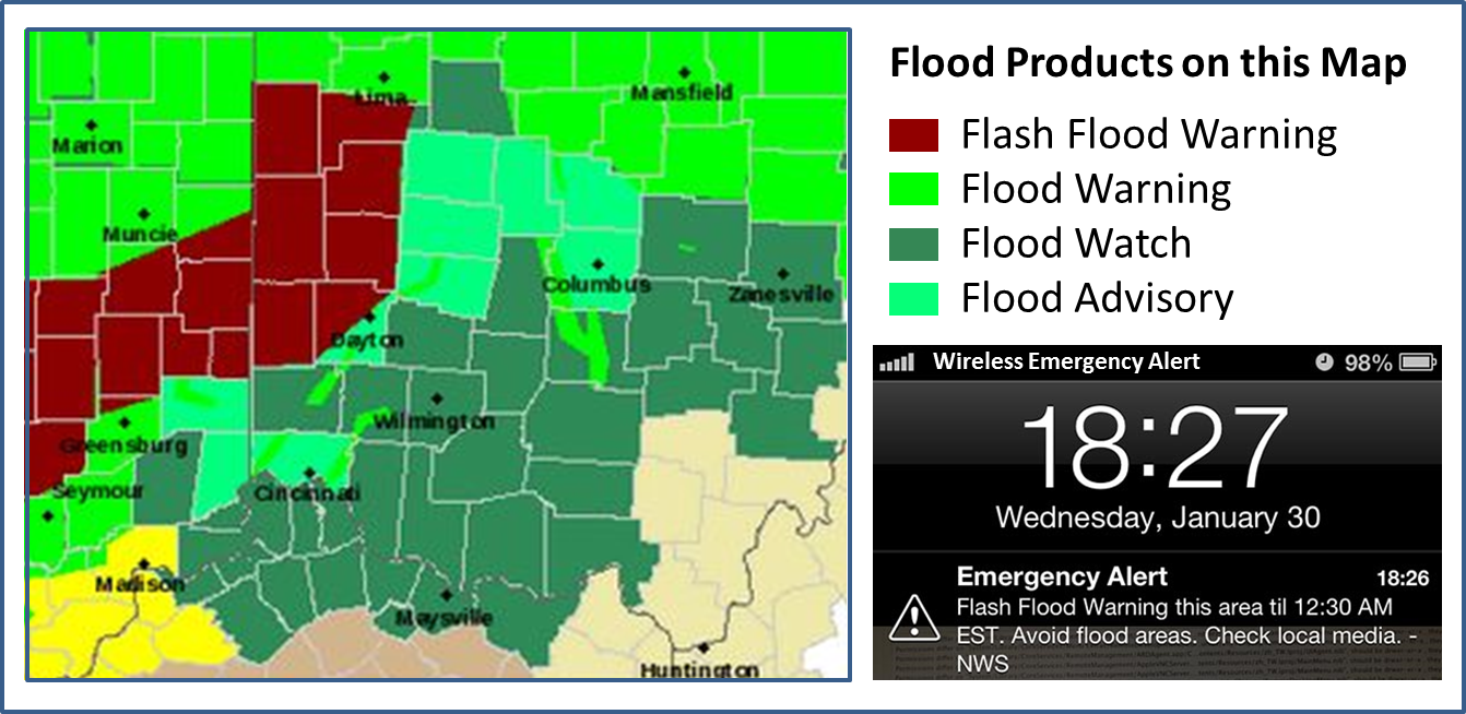
6. Types of Warnings and Their Meanings
It’s crucial for the public and agencies to understand different flood-related alerts. Various jurisdictions may use slightly different terms, but commonly:
Flash Flood Watch (or Advisory)
-
Meaning: Flash flooding is possible in your area.
-
Action: Stay alert, monitor weather updates, prepare to act.
-
Nature: Preemptive; issued before flooding begins when conditions favor flash floods.
-
When used: When forecast models, radar, or watershed indices suggest enough rain that flooding might occur.
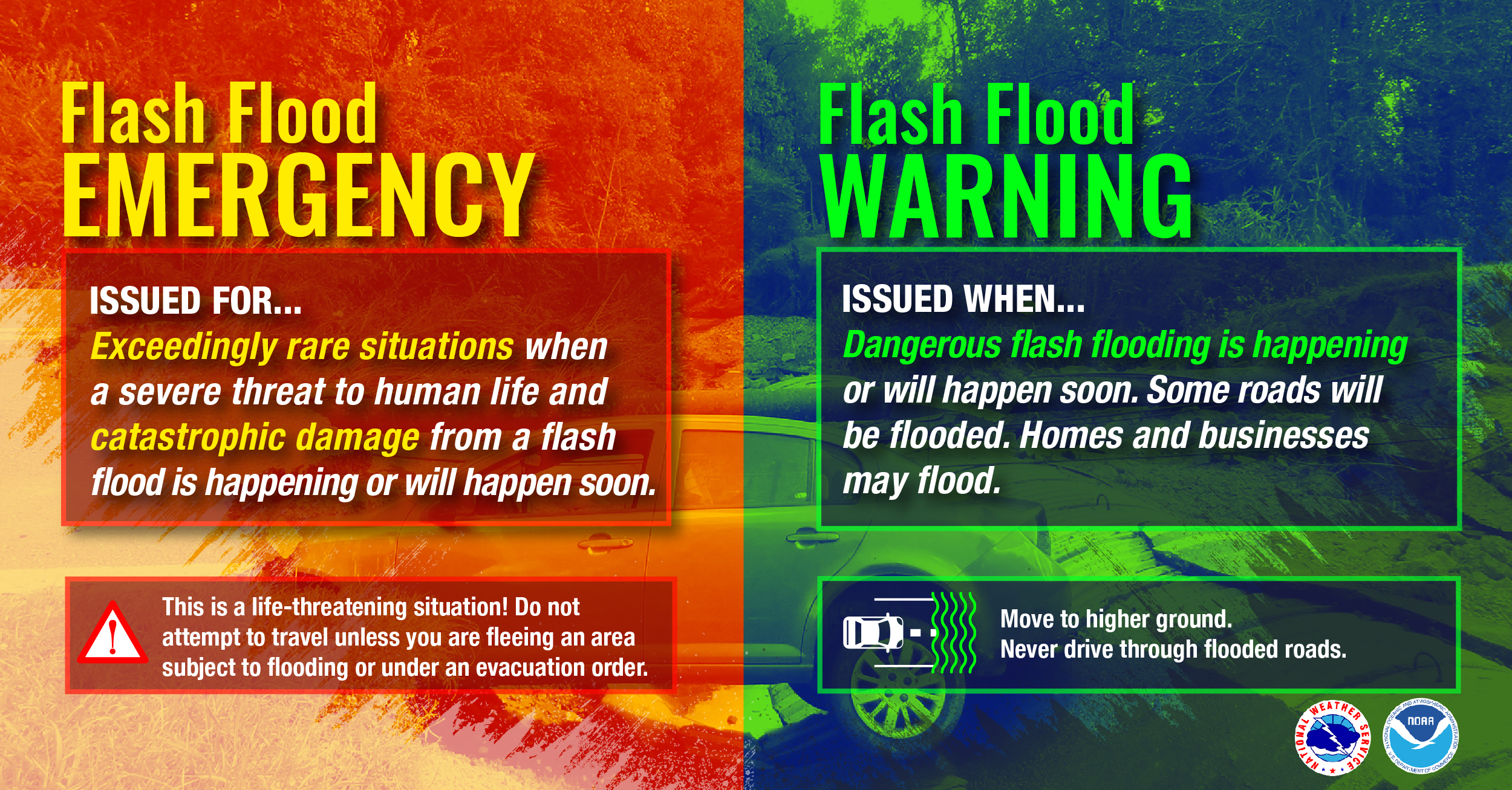
Flash Flood Warning
-
Meaning: Flash flooding is occurring or is imminent in the warned area.
-
Action: Take immediate action — move to high ground, evacuate if necessary, avoid flood-prone areas.
-
Nature: Reactive / imminent; issued when flooding is already happening or just about to happen.
Flash Flood Emergency (or “Particularly Dangerous Situation”)
-
Meaning: Catastrophic, life-threatening flash flooding is occurring or expected imminently.
-
Action: This is a top-tier alert — immediate and urgent action; often associated with widespread rescues and evacuations.
-
Rarity: Issued rarely, only in extreme situations.
Flood Warning vs. Flash Flood Warning
-
A Flood Warning generally refers to longer-duration flooding (riverine or slow-onset) and is used when river levels are rising or expected to rise above flood stage.
-
A Flash Flood Warning is more urgent, referring to rapid-onset flooding.
Flood Advisory
-
Meaning: Minor flooding is expected; could cause inconvenience or localized damage but generally not life-threatening.
-
Action: Be cautious, avoid low-lying areas, and monitor conditions.
Understanding this hierarchy helps the public interpret alerts and respond appropriately.
7. Public Response, Preparedness, and Safety Measures
A warning is only useful if people know how to respond. Here are key strategies, guidelines, and advice.
Preparedness Before the Rain
-
Know your flood risk: Consult flood maps, topography, past event history, and local emergency management to know if your home, workplace, or commute falls in flood-prone zones.
-
Plan evacuation routes and safe zones: Identify higher ground, safe shelters, and escape paths (roads less likely to flood).
-
Assemble an emergency kit: Include essentials (water, food, first-aid, flashlight, batteries, documents, medications, etc.).
-
Secure your home: Move valuables to higher floors, install floodproofing if possible, check drainage around your property, ensure gutters and drainage are cleared.
-
Stay informed: Sign up for local alert systems, keep weather radio, monitor forecasts, and maintain a way to receive sudden alerts (e.g. mobile alerts).
What to Do During a Flash Flood Warning
-
Act quickly: Don’t wait. Move to higher ground immediately.
-
Avoid driving through floodwater: The phrase “Turn Around, Don’t Drown” is widely used because many fatalities occur when people attempt to drive through submerged roads, underpasses, or narrow crossings. Even as little as 6 inches of fast-moving water can knock a person off their feet; 12 inches (1 foot) may carry away a small car.
-
Don’t walk through flowing water: Water hides hazards (sharp debris, holes, strong currents).
-
Obey official instructions: Evacuate if directed, follow route guidance, and don’t return until authorities say it’s safe.
-
Avoid bridges or paths over fast-moving water: Even if street looks solid, underlying support could be compromised.
-
Seek interior rooms on higher floors if trapped: If you cannot escape your building, move to highest safe point.
-
Turn off utilities if safe to do so: Electrical, gas, water (but only if you can do so safely and quickly).
-
Avoid contacting electrical equipment when wet or standing in water.
After the Flash Flood
-
Stay updated: Monitor official channels to know when it’s safe to return.
-
Don’t cross floodwater: Return only when authorities confirm safety.
-
Avoid damaged buildings or roads: They may be unstable.
-
Check for hazards: Downed power lines, gas leaks, contaminated water, hidden debris.
-
Document damage: Take photos for insurance claims.
-
Be a good neighbor: Assist vulnerable people around you (elderly, disabled, children).
Key Public Messaging Principles
-
Use clear, nontechnical language.
-
Emphasize urgency (when a warning is in effect).
-
Use multiple communication modes to reach various segments (SMS, radio, loudspeakers, sirens, social media).
-
Provide actionable instructions, not just general warnings.
-
Encourage rehearsal and education ahead of time.
8. Challenges and Limitations in Flash Flood Warning Systems
Despite advances, flash flood warning is inherently difficult. Below are major challenges:
Very Short Lead Time
Flash floods can develop in minutes. This leaves limited time for detection, decision-making, dissemination, and response.
Sparse Observation Networks
In many regions, rain gauges or stream gauges may be sparse or absent, especially in remote or developing regions. This limits real-time data availability needed for accurate forecasts.
Model and Forecast Uncertainty
Hydrological models have limitations in capturing small-scale rainfall variability, soil infiltration properties, or complex basin features. This leads to false alarms or missed events.
False Alarms / Over-warnings
To be safe, forecasters sometimes issue warnings even if flooding is uncertain. But too many false alarms can erode public trust and lead to “warning fatigue” (people ignore alerts).
Public Comprehension and Response Barriers
-
Some people may not understand the difference between warnings, advisories, watches, etc.
-
Over-alerting may desensitize people.
-
Low literacy, language barriers, or distrust in authorities can impede response.
-
Physical limitations (elderly, disabled) or lack of transportation may prevent timely evacuation.
Communication Infrastructure Failures
During heavy storms, power outages, network failures, or damaged infrastructure may prevent alerts from reaching the public or communications between agencies.
Topographic and Local Variability
Micro-scale terrain effects, small channels, or local drainage peculiarities may produce flooding in unexpected locations that models or forecasts may not fully anticipate.
Legal and Liability Considerations
Forecasting organizations must balance issuing warnings vigilantly versus the costs or consequences of false alarms. There may be legal or reputational risks.
Post-Event Validation
Confirming what happened—especially in remote or small basins—can be challenging, which makes refining thresholds or models more difficult.
9. Case Studies and Examples
Here are some illustrative flash flood events and how warnings (or lack thereof) played roles.
2024 Mai Mahiu Flash Flood, Kenya
On 29 April 2024, a flash flood around Mai Mahiu killed at least 61 people and left many missing. The cause was partly a culvert blockage beneath a railway embankment failing after heavy rains.
This event showed how infrastructure failures (culvert blockage) can convert normal drainage into catastrophic flooding.
2025 Uttarakhand Flash Flood, India
In August 2025, an outburst flood (possibly from glacial or high-altitude source) triggered a flash flood in the Dharali area. Hundreds of people were feared trapped; at least five casualties were initially confirmed.
The remote terrain and difficulty in communication likely exacerbated the challenges of issuing warnings and organizing rescue.
2020 North Luwu Flash Flood, Indonesia
Heavy rainfall (300–400+ mm) caused flash floods in North Luwu in July 2020. More than 4,000 houses were damaged, many people were displaced, and at least 38 died, with dozens missing.
The severe damage demonstrates how extreme rainfall over a short period can overwhelm communities, even if they expect flooding.
U.S. Examples
-
In many U.S. jurisdictions, the National Weather Service issues flash flood warnings with short lead times, sometimes using radar-based predicted rainfall and flood guidance thresholds.
-
The “Turn Around, Don’t Drown” campaign has been used in the U.S. to educate drivers not to enter flooded roadways.
These cases highlight both successes and failures: in some, effective warning and response saved many lives; in others, the speed and unpredictability overwhelmed systems and communities.
10. Lessons Learned and Best Practices
From analysis of past events globally, here are key lessons and practices that improve flash flood warning effectiveness:
-
Integrated Observation Systems
Ensure dense and redundant networks of rain gauges, stream gauges, radar, satellite systems, and remote sensors. -
Improved Modeling and Real-Time Analytics
Use high-resolution hydrologic / hydrodynamic models, machine learning, and real-time assimilation to refine predictions. -
Tailored Local Thresholds
Develop flood thresholds specific to local basins, channels, and terrain features (i.e., not “one size fits all”). -
Multi-Channel Alert Dissemination
Use diverse and overlapping communication methods (radio, TV, cell broadcast, sirens, social media). Avoid single points of failure. -
Clear Public Messaging & Education
Educate communities on what warnings mean, how to respond, and preplan routes and safe zones. Use drills and community outreach. -
Minimize False Alarms
Balance sensitivity and specificity in warning issuance to maintain public trust. Use probabilistic forecasts or “impact-based” warning systems to communicate severity. -
Coordination Across Agencies
Meteorological, hydrological, civil defense, emergency management, and local governments must coordinate closely, with protocols, communication channels, and rehearsals. -
Real-Time Verification and Feedback
Use ground-based spotters, community reports, and post-event data to validate and adjust models and warning logic. -
Equity and Accessibility
Ensure that alerts reach vulnerable populations (illiterate, elderly, rural, non-technical) via inclusive communication (e.g. sirens, voice alerts, community liaisons). -
Infrastructure Resilience and Mitigation
Design urban drainage, culverts, retention basins, green infrastructure, and zoning practices to reduce flood vulnerability. That reduces the burden on warning systems.
11. Recommendations for Improvement
Based on current challenges and lessons, here are actionable recommendations (which could be adapted to Cambodia or other regions) to strengthen flash flood warning systems:
-
Expand Observational Infrastructure
-
Install more rain gauges, telemetry-enabled stream gauges, and automated sensors in critical basins.
-
Use crowd-sourced rainfall and water-level reporting (mobile apps) to supplement official networks.
-
-
Leverage Remote Sensing and AI
-
Use high-resolution radar and satellite rainfall products.
-
Develop machine learning models to detect flash flood onset patterns.
-
Use neural networks to detect anomalies and trigger alerts faster.
-
-
Adopt Impact-Based Warning Frameworks
-
Rather than binary “warning or no warning,” include expected severity (minor, moderate, major) and expected impacts (life-threatening, damaging).
-
This helps the public and authorities prioritize responses.
-
-
Strengthen Communication Channels
-
Use wireless emergency alerts (cell broadcasts) with short, clear messages.
-
Deploy sirens or public address systems in vulnerable zones.
-
Work with media partners (radio, TV) to carry urgent alerts immediately.
-
Use social media and popular messaging apps where appropriate for supplementary communication.
-
-
Public Education Campaigns
-
Conduct community drills and training on flash flood response.
-
Promote mnemonic slogans (e.g. Turn Around, Don’t Drown).
-
Use community resilience programs linking local leaders to forecasting agencies.
-
-
Local Threshold Calibration
-
For key drainage basins, calibrate rainfall-to-flood thresholds based on historical events.
-
Update thresholds as land use or drainage changes.
-
-
Post-event Analysis and Learning
-
Institutionalize after-action reviews to analyze every flash flood event: successes, failures, model performance, communications, public response.
-
Adjust models, protocols, and thresholds accordingly.
-
-
Incorporate Climate Change Projections
-
Anticipate that extreme rainfall events may intensify in many regions due to climate change; design systems to be robust under more extreme conditions.
-
-
Community-Based Monitoring and Early Warning
-
Engage locals (villagers, watershed communities) to monitor water levels, barrier conditions, and trigger local alerts.
-
Offer training and simple tools (float gauges, measuring sticks).
-
-
Integrate with Land-Use Planning and Mitigation
-
Avoid building in flood-prone low-lying zones.
-
Maintain natural drainage paths and riparian buffers.
-
Promote permeable surfaces, green infrastructure (swales, retention ponds), and stormwater management.
-
-
Ensure Redundancy and Backup Capability
-
Use backup power, redundant communication paths, and multiple alerting methods in case one fails.
-
-
Institutional and Policy Support
-
Secure funding, legal mandates, institutional coordination, and capacity building for meteorological, hydrological, and emergency agencies.
-
12. Conclusion
Flash flood warnings are one of the most critical tools in protecting life and property in rapidly evolving weather events. Because flash floods can develop with little warning, the system that supports detection, decision-making, communication, and public response must be robust, fast, and well-integrated.
While no system is perfect, combining advanced monitoring, modeling, public education, and resilient communication infrastructure dramatically increases the odds of responding effectively. The lessons from past disasters highlight the importance of local calibration, inclusive communication, and ongoing adaptation.
Trend breakdown
flash flood warning
phoenix weather
weather phoenix


No comments:
Post a Comment